This month we celebrate the lake! October marks the month that a very wet forecast filled Lake Conroe—in less than nine months—back in 1973.
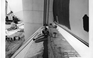
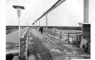
Lake Conroe was constructed by the San Jacinto River Authority through a partnership agreement with the City of Houston and the Texas Water Development Board in 1968 to serve as a water supply reservoir for the City of Houston, which owns two-thirds of the water rights in the reservoir. Like most of the reservoirs in Texas, Lake Conroe was planned and constructed shortly after the record seven-year drought of the 1950s as part of a reservoir-building boom intended by state water planners to prevent a repeat of the water shortages experienced during the drought.
The headwaters—or source—of Lake Conroe, is formed by the West Fork of the San Jacinto River, located about 17 miles west of Huntsville in western Walker County. The lake covers a 21,000-acre area that extends about 21 miles from the dam to the upper reaches of the West Fork, with 5,000 acres lying in the Sam Houston National Forest. The lake can store up to 430,000 acre-feet of water at the normal pool elevation of 201 feet above Mean Sea Level. Downstream of the Lake Conroe Dam, the San Jacinto River flows southeast for about 90 miles through Montgomery County to its confluence with the East Fork of the San Jacinto River in northeastern Harris County, then into the northern rim of Lake Houston.
The San Jacinto River Authority (SJRA) is proud to have had a role in Lake Conroe from the very beginning. Located at the Lake Conroe Dam, the SJRA Lake Conroe Division’s primary functions include: municipal and industrial raw water supply, reservoir operations, water quality and source water protection, invasive species management, navigational safety, and regulation of structures on the reservoir.

SJRA’s primary focus has always been and will continue to be water supply development. In September 2009, following years of negotiations, the SJRA completed a contract with the City of Houston to purchase the right to use the City’s two-thirds share of the water supplies in Lake Conroe in order to provide this valuable resource to Montgomery County. This important acquisition makes all of the water in Lake Conroe available for Montgomery County’s expansive growth.
Beginning in 2015 Lake Conroe began to supplement groundwater (underground aquifer) sources in Montgomery County as a source of drinking water. Rapid population growth and the resulting increase in water demand in the county has made it even more important to supplement the county’s groundwater supply, and prompted the Lone Star Groundwater Conservation District to mandate a reduction in groundwater withdrawals. The SJRA responded to this mandate by entering into voluntary agreements with over 80 public and private entities in Montgomery County to construct a water treatment plant at Lake Conroe using surface water from the lake in order to create a more balanced approach to supplying the water needs of the growing Montgomery County area.
The SJRA’s history of water supply acquisitions has made it possible for Montgomery County to have reliable, cost-effective water supplies to meet its future water needs.
In addition to securing water supply, SJRA also manages the operation and care of Lake Conroe. For 40 years, aquatic vegetation has been a great concern in Lake Conroe. More recently, there have been joint efforts between Texas Parks and Wildlife (TPWD) and SJRA to help preserve the natural habitat of Lake Conroe. TPWD and SJRA partner together to engage in aquatic management on the lake. Aquatic management includes both native and exotic (non-native) species. The goal is to increase the number of native plants while limiting exotic species. Some of the benefits of the native species planting is that it creates fish habitat, allows for erosion protection, and serves as a nursery for pulling transplants later.
Lake Conroe Facts:
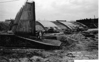
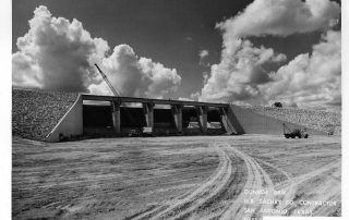
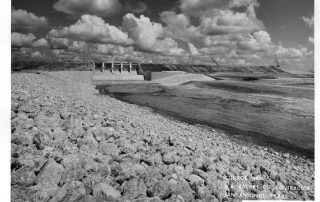
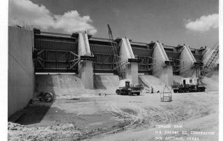
The Dam:
- Type: Earth Filled
- Year completed: 1973
- Outlet structures: two concrete outlets, one service spillway and one service outlet
- Service spillway: five gates, 40 feet wide and 30 feet high, utilized for floodwater releases.
- Service outlet: 3 gates with a 10 foot diameter conduit, utilized for releasing water downstream (Lake Houston).
- Top of dam elevation: 212 feet above mean sea level.
- Width of Dam: 2.2 miles (11,280ft)
- Maximum height: approximately 82 feet (top of dam structure)
- Maximum gate opening: approximately 20 feet per gate.
- Maximum possible release: approximately 150,000 cubic feet per second (depends on lake level during release)
- Highest gate opening in history: 14 feet per gate on August 28, 2017 (previous record was 6 feet per gate on October 19, 1994).
The Lake:
- Surface acres: 19,640.
- Watershed drainage area: Approximately 450 square miles.
- Shoreline: approximately 150 miles
- Capacity: 412,200 acre feet.
- Average depth: 20 feet.
- Normal pool elevation: 201 feet above mean sea level.
- Maximum release in history: 79,141 cubic feet per second on August 28, 2017 (previous record was 33,000 cubic feet per second on October 19, 1994).
- Flowage easement: (area we can raise the lake up to during a flood event) 207 feet above mean sea level.
- Highest level in history: 206.24 on August 28, 2017 (previous record was 205.58 on October 19, 1994).
- Lowest level in history: 192.68 (8.32 feet) on December 2, 2011 (previous record was 196.02 on January 12, 1989).
- Average bulkhead height: elevation 203 feet above mean sea level.
- Annual rainfall: average 48 inches.
- Maximum evaporation rate: approximately 180 million gallons per day.