Grants to aid in flood mitigation projects
In June, San Jacinto River Authority (SJRA) submitted five abridged applications to the Texas Water Development Board (TWDB) for grants to aid in flood mitigation. The grants are funded by the Flood Infrastructure Fund (FIF), a program made possible by Senate Bill 7 sponsored by Senator Brandon Creighton in the last legislative session. The fund is made up of loans and grants that must meet specific criteria. In the two-stage process, applicants must first submit an abridged application for each project. Based on the abridged applications, TWDB will rank the projects based on multiple criteria and prioritize them within the overall available funding capacity. The proposed projects selected from the first round of submittals are then eligible for submittal as full applications. According to FIF criteria, eligible projects must fall under one of four categories:
- Flood Protection Planning for Watersheds
- Planning, Acquisition, and Design, Construction/Rehabilitation
- Federal Award Matching Funds
- Measures Immediately Effective in Protecting Life and Property
SJRA has applied for grant assistance to help support five different projects that each fall within one of the FIF categories.
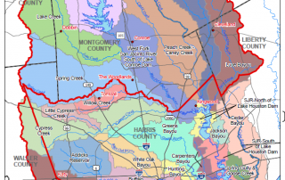
Upper San Jacinto River Basin Regional Sedimentation Study:
The purpose of this project is to perform a regional sedimentation study of the Upper San Jacinto River Basin (Lake Houston watershed). Sedimentation in the Upper San Jacinto River Basin has been well documented, and is known to impact floodway conveyance capacity. In order to identify and create a plan for implementing potential sedimentation solutions, this study will develop “sediment budgets” by evaluating the input, output, and storage of sediment for the entire basin, as well as for sub-watersheds within the basin. Specific tasks anticipated to be included in the scope of work for the project include, but are not necessarily limited to:
- Upper San Jacinto River Basin watershed characterization
- Inventory of available existing data
- Annual sediment output determination
- Annual sediment storage determination
- Sediment transport modeling
- Individual sediment source or storage locations determination
- Individual site investigations
- Key stakeholder and permitting agency coordination
- Development of conceptual solutions and overall implementation strategy
- Development of Upper San Jacinto River Basin sediment management plan
San Jacinto River Sand Trap Development Preliminary Design:
House Bill 1824, approved by the 86th Texas Legislature, allows SJRA and the Harris County Flood Control District (HCFCD) to remove material from the San Jacinto River and its tributaries to restore, maintain, or expand storm flow capacity without the need for state permitting or a royalty payment to the state. SJRA is leading efforts, with support from HCFCD, to perform a project to plan, design, and construct one or more “sand traps” along the West and/or East Forks of the San Jacinto River to reduce future sedimentation with the goal of mitigating flooding.
This small scale effort, involving only one or two sand traps, is intended to act as a “pilot” project from which data can be gathered as to the real-world feasibility and effectiveness of sand traps in removing material from the river(s) and mitigating sedimentation issues in the basin before a larger, and much more costly, program is potentially embarked upon. In order to continue the project beyond the conceptual design phase, and especially through construction, even on this relatively small pilot scale, additional funding is anticipated to be required to supplement available local match resources.
Preliminary design efforts could include, but are not limited to, environmental permitting investigation, preliminary land acquisition efforts, survey, geotechnical investigation, and 30% design efforts. Preliminary conceptual design phase results indicate that the sand traps recommended to move forward to preliminary design will likely be located along the West Fork of the San Jacinto River.
Spring Creek Watershed Flood Control Dams Conceptual Engineering Feasibility Study:
The purpose of this project is to perform a conceptual engineering feasibility study of two potential dams/reservoirs within the Spring Creek watershed. This project is proposed as a continuation or next phase of the Spring Creek Siting Study, which is currently being completed as a sub-task to the San Jacinto Regional Watershed Master Drainage Plan project being performed by HCFCD and supported by SJRA and other regional partners.
The Spring Creek Siting Study, still in draft form, has identified two dam/reservoir construction locations within the Spring Creek Watershed, along Walnut Creek and Birch Creek, which have potential to provide flood mitigation benefits to the watershed.
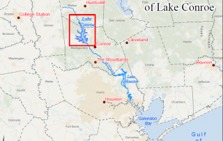
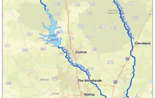
Lake Conroe – Lake Houston Joint Reservoir Operations Study:
The purpose of this project is to develop a joint reservoir operations strategy for Lake Conroe and Lake Houston. The City of Houston is currently in the design phase of a project to add new tainter gates at the Lake Houston dam which could greatly increase the controlled release capacity of the dam. Once these gates are in place at Lake Houston, it will be beneficial to both water supply and flood mitigation in the region for a joint operations plan to be in place. The main goal of the plan is to determine the most efficient and safe operation of the two reservoirs in series by evaluating multiple individual components of operational strategy. The project will include evaluation of the operational synergy between the two reservoirs, joint notification and communications protocols, pre-release, impacts on water supply, and the use of forecasting tools.
Flood Early Warning System for San Jacinto County:
A Flood Early Warning System grant would provide for installation of rain and river/stream stage gaging equipment at three locations identified as critical by San Jacinto County to provide early warning information to the county during storm events. The identified gage locations are Winters Bayou at State Highway 150, East Fork San Jacinto River at FM 945, and Peach Creek at FM 3081. At each location, equipment to be installed would include mounting pole, enclosure with antenna mast and rain gage, river/stream stage sensor, alert transmitter/sensors, and all other related and necessary equipment and appurtenances. Rain and river/stream stage data obtained at the sites would be transmitted to SJRA’s ALERT2 network and displayed on SJRA’s Contrail system which can be viewed online via SJRA’s website, allowing San Jacinto County staff and residents to easily access and view the data at any time.
TWDB is currently in the process of reviewing submitted abridged applications. SJRA looks forward to the opportunity to submit full applications on some or all of the above described projects.
To stay updated on SJRA’s status with the FIF, please visit our blog. Future posts on the status of the grant will be uploaded during the process. For more information regarding the FIF and the application process, visit: https://www.twdb.texas.gov/financial/programs/fif/index.asp
One of the major river authorities in Texas, SJRA’s mission is to develop, conserve, and protect the water resources of the San Jacinto River basin. Covering all or part of seven counties, the organization’s jurisdiction includes the entire San Jacinto River watershed, excluding Harris County. For additional information on SJRA visit our website at www.sjra.net, like SJRA on Facebook @SanJacintoRiverAuthority, follow us on Twitter @SJRA_1937, find us on Instagram @sanjacintoriverauthoritySJRA, or connect with us on LinkedIn @San Jacinto River Authority.